Exploration
Contents
Exploration#
Last edited: 01 Sep 2023
Author(s): Andrea Balza (RWTH Aachen, Germany - ETH Zurich, Switzerland)
Hagen Söding (ETH Zurich, Switzerland - RWTH Aachen, Germany)
Mahmoud Eltayieb (TU Delft, Netherlands - ETH Zurich, Switzerland)
Geothermal exploration is the process of searching for and identifying areas in the Earth’s crust that have the potential to host geothermal energy resources. It involves a comprehensive assessment of the geological and geophysical properties of the target area, including rock and fluid filling rock properties, temperature and pressure gradients, and the extent of heat sources.
Where do we explore?#
Geophysical exploration is the study of the physical properties of the Earth. Geothermal energy production is possible in areas where heat sources are relatively shallow, allowing heat from the Earth’s interior to be easily harnessed. Some areas that are ideal for geothermal energy production include: `
Ideal areas for geothermal energy production
Volcanic regions: Regions with active or dormant volcanoes are often good sites for geothermal energy production, as they have high levels of heat flow and permeable rocks.
Rift zones: Areas where the Earth’s crust is being pulled apart, such as along the Mid-Atlantic Ridge or the East African Rift, can provide access to hot rocks and geothermal reservoirs.
Subduction zones: These are areas where tectonic plates are colliding, and one plate is being forced beneath another. This process can cause magma to rise to the surface and create hotspots for geothermal energy production.
Geologic evidence on the surface and rock samples are studied to understand the formation of these different zones. After geological information confirm a geothermal potential, geophysicists proceed to use geophysical instruments to explore the subsurface of a specific location.
How do we explore by using geophysics?#
In geothermal exploration, the targets are usually located a few kilometres underground. Thus, direct exploration, for example drilling exploratory wells, is expensive and gives information only around the borehole. This makes geophysical techniques that can image the underground from the surface highly attractive.
When trying to understand geophysical imaging, it helps to visualise a scenario that is close to our everyday life. For example, when using imaging an organ in the body, an ultrasound source is placed on the body and emits a soundwave. When this wave encounters different parts of the body, the sound wave will be refracted and/or reflected. From the amplitude and the time between sending and receiving the wave, we can create an image of the organ. The same concept is used in seismic exploration, where sound waves are emitted into the subsurface, again building an image of the geothermal reservoir from the refractions and reflections.
When imaging the underground for geothermal exploration, we normally deploy our sources and receivers on the surface. Thus, we are usually a few kilometers (1-5km) far from the geothermal reservoir, that we want to image. This is why we often look for key features like big faults in the reservoir, that are still visible on the geophysical measurements. These faults are necessary pathways for geothermal fluids, which allow heat production. These pathways are one of the elements indicating geothermal potential and drilling further investigates the geothermal heat. Geophysicists employ a variety of explorations techniques, to get the best image of the underground:
Techniques often used for geothermal exploration
Gravity: Rocks of different densities alter the gravitational field of the earth very slightly. Measuring the gravitational field at the surface of the earth allow us to detect areas with dense or less dense material.
Seismics: Using waves from ground motion to capture information of the subsurfaces where they pass throught. Seismometers record the movement at certain locations thus gives us insight into the underground.
Electromagnetics: Simliar to Seismics, electromagnetic methods use electromagnetic waves travelling in the subsurface. These can be generated by humans, and from the solar wind interatting with the earths magnetic field and lightnings.
Seismic#
One of the most important methods of imaging the earth are seismic waves. Seismic waves are waves of ground motion, that travel through the earth. Just like in ultrasound, these waves get reflected and refracted at obstacles and boundaries and carry lots of information about the underground structure. The field that studies seismic waves is called seismology and has traditionally investigated earthquakes to among others understand the structure of the earth.
In exploration geophysics we also use seismic waves to image the shallow layers of the subsurface, to understand its structure. Therefore exploration seismolgist use a variety of techniques, to produce small, human-made earthquakes. For small depths, a hammer with a metal plate is enough to generate a wave, that travels tens of meters into the underground. If you need the waves to travel deeper into the earth, more energy is needed. Therefore, we either use explosives or vibration trucks to create stronger waves, that can travel kilometers deep into the earth crust.
To record the seismic waves, one uses so called geophones instead of seismometers. These consist of a metal pin, that gets firmly inserted into the ground. Attached to the metal pin is an accelerometer, that picks up the ground movement. For a seismic survey, a handful of geophones is laid out on the surface about the reservoir, that we want to image. After installing all the geophones, the sources get placed at different positions at the geothermal site, and at each site, an experiment is conducted. After all experiments at the source locations have been conducted, all the recorded data is collected and passed to a geophysicist for analysis. By analysing all the reflections picked up at the geophones, a detailed image of the underground can be produced. From this image, scientist deduce the location and depth of important fault zones and layers to decide, where exploratory wells should be drilled.
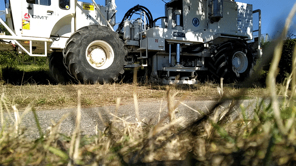
Fig. 3 A vibrotruck is acquiring data in a seismic survey for the Einstein telescope. The metal plate vibrates thereby creating seismic waves used for exploration.#
Gravity method:#
Gravity is the force by which a planet or other body draws objects towards its center. In geophysics, gravity is used to study the distribution of mass in the Earth’s subsurface. A gravity survey involves measuring the gravitational pull of the Earth at various locations on the surface. This changes due to the density or mass of the bodies that are within the Earth. Geophysicist use a device called a gravimeter to make these measurements. By measuring tiny changes in gravitational force, scientists can create maps that show areas where the Earth’s subsurface contains more or less mass. This can help identify features associated to geothermal systems such as plumes, basement level, and granite volumes.
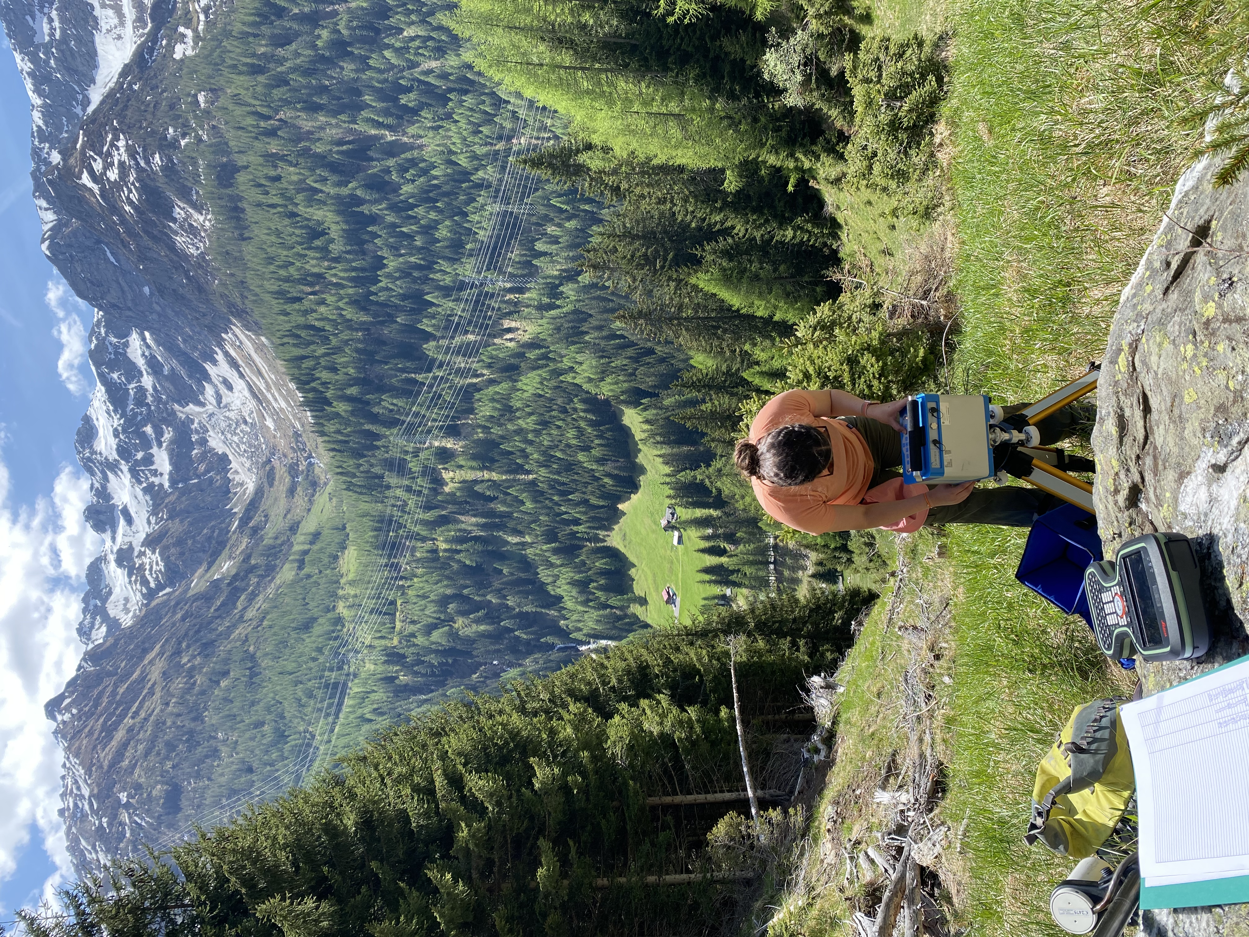
Fig. 4 Acquiring gravity data in the field.#
Electromagnetic methods:#
Electromagnetic (EM) waves are waves of energy that travel through space and can be used to study the Earth’s subsurface. In geophysics, EM methods involve sending EM waves into the ground and measuring their response. EM surveys can be conducted using different frequencies and techniques. When EM waves encounter different types of rocks and minerals in the subsurface, they can induce electrical currents to flow. By measuring these currents, we can create maps that show variations in the subsurface electrical properties. This can help identify areas with different rock types, especially areas that are conductive such as areas of high heat flow. A common method done under this realm of geophysical techniques is the magnetollueric method or MT. This method is used to study the electrical conductivity structure at a much deeper scale. It involves measuring the natural variations in the Earth’s magnetic field and electric field at the Earth’s surface, and using these measurements as the source. By analyzing the frequency-dependent variations in these fields, we can estimate the electrical resistivity of different rock layers and fluids in the subsurface which is of great importance in geothermal exploration.
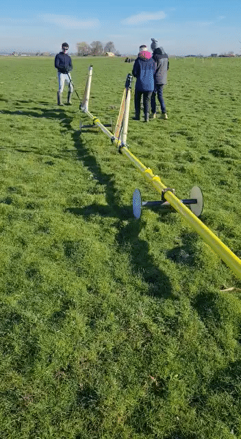
Fig. 5 Acquiring data in a EM survey.#
Exploratory well drilling#
Exploratory wells are drilled to get detailed information about the subsurface, which includes the properties of geothermal reservoirs. They are drilled into the earth’s crust until reaching the geothermal fluids like water or steam. These fluids are heated by the earth’s internal energy. The fluids are then pumped to the surface and analyzed for their temperature, pressure, chemistry, and other properties.
Exploratory wells also help to determine the size and potential of a geothermal resource. This information is critical for assessing the feasibility of a geothermal power plant and estimating its potential power output. Exploratory wells can also help to identify the characteristics of a geothermal reservoir, such as its permeability, porosity, and fracture network. Geothermal engineers use this information to determine optimal locations for production wells, which in turn ensures efficient and sustainable use of the geothermal resource.
Exploratory drilling is used for collecting well logs. For these logs, specialized tools are lowered into the wellbore and record various physical properties of the rock formations around the borehole. Here are some of the most common types of well logs:
Common types of well logs
Electrical Logs: measure the electrical properties of the rock formations encountered during drilling.
Acoustic Logs: measure the time it takes for sound waves to travel through the rock formations, as well as the amplitude and frequency of the waves.
Nuclear Logs: use radioactive sources to emit gamma rays or neutrons into the rock formations, and measure the radiation that is emitted back.
Imaging Logs: use various techniques to create images of the wellbore and the surrounding rock formations.
Temperature Logs:measure the temperature and distribution within the borehole to learn about the heat flow.
Other Logs: Other types of well logs include e.g. pressure logs and production logs.
Overall, the use of multiple types of well logs can provide comprehensive data about the subsurface geology and rock properties and assists to identify potential geothermal reservoirs. For example, the presence of high porosity and permeability in certain rock formations within the borehole can indicate the presence of a geothermal reservoir, as these properties are important for the storage and movement of hot fluids.
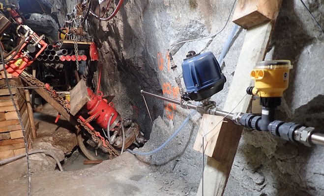
Fig. 6 A tunnel rig in the Bedretto Underground Laboratory drilling boreholes for hydraulic stimulations.#
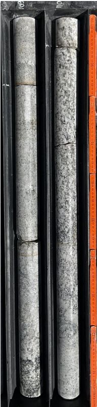
Fig. 7 Core samples from the BULGG.#
Geochemistry for geothermal exploration#
Another important role of exploratory wells is to assess the potential output of geothermal resources by providing access to subsurface geothermal fluids and rocks. The sampled geothermal fluids and rocks can then be studied via geochemical techniques.
Geochemistry is the study of the chemical and physical processes that occur in rocks, minerals, and fluids in the Earth’s crust. To find geothermal resources, we use geochemistry to identify areas with high temperatures and to understand the nature of the fluids and rocks underground. Geochemical techniques, such as isotopic analysis, and mineralogical studies, help to assess the feasibility of developing a geothermal resource. Sometimes, gases like carbon dioxide, hydrogen sulfide, and methane are released from the Earth’s subsurface, which can provide clues about the geothermal system below. For example, the chemicals and gases can indicate local pressure and temperature regimes within the geologic setting. Geochemistry can also help identify faulted areas and quality of connected fracture networks that are made by hydraluic stimulation. In conclusion, measuring the type and amount of gases, the temperature (which is done in the field of geothermometry) and location of the geothermal reservoir can be estimated.
Geochemistry in geothermal production
Geochemical analysis is also used to monitor geothermal production. Geochemists use techniques to determine the chemical composition of geothermal fluids including the presence of dissolved gases, minerals, and trace elements to evaluate the potential for mineral scaling and corrosion. This is important, since scaling and corrosion can impact the efficiency and longevity of geothermal power plant operations. For more information about the risks involved in these processes refer to Issues and Safety of Geothermal Operations
From data to subsurface models - Geophysical Inversions#
When investigating a geothermal site, we usually have a simple geological model of the subsurface in advance, but the real subsurface is often way more complex. Once we have collected sufficient data in a geophysical survey, we build an idealistic model that is close to realistic, that explains our measured data.
Given our simple geological model, we can validate our model guess by simulating our geophysical method and comparing the simulated to the measured data. Calculating simulated data from a model and comparing it to our recorded data is commonly referred to as forward modelling.
If we do not have a good match between the simulated data from our simple model and the recorded data, we update the model step by step, by including more details, until our model explains the recorded data. Therefore we would calculate, if increasing a model parameter leads to an improvement or worsening in the fit between our simulated and recorded data. If a slight increase leads to an improvement in the fit, we would then update the model accordingly and otherwise decrease the model value slightly. This stepwise procedure is called optimisation and the whole process of building a model from recorded data is referred to as inverse modelling.
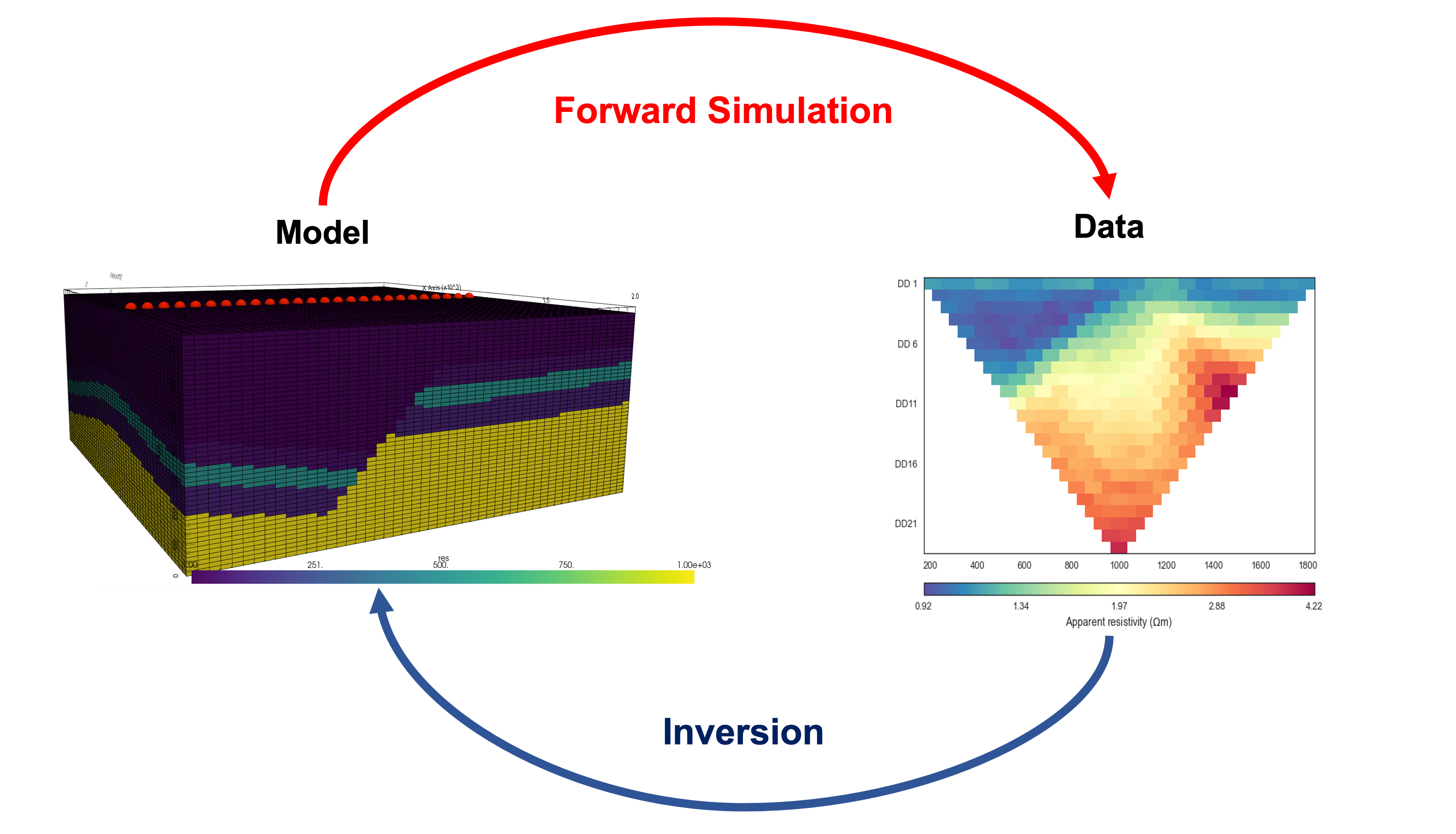
Fig. 8 Forward modelling vs. inverse modelling.#
Modelling#
Geologic model#
Once the geophysical inversion has been completed, we use this result to create a geological model of the subsurface. Geological modelling is a critical component of geothermal exploration. Geothermal exploration and targeting the best sites for drilling depends on understanding how various geological features interact to control fluid flow and resource characteristics [13]. Geothermal resources are often located in complex geological settings, making it essential to create a detailed model of the subsurface geology to identify potential geothermal reservoirs. The geological model incorporates data from the geophysical inversion with other geological data such as drill cores, well logs, and surface mapping. Geologists also create models of the different structural features present in the subsurface, such as faults and fractures. These models help to understand the subsurface geology and identify areas where geothermal fluids may accumulate. A wide range of computer software is used to create a 3D model of the subsurface geology which incorporates the different data types, allowing geologists to visualize the subsurface geology in three dimensions. Below is an example of a 3D geologic model of the Utah Forge geothermal test site.
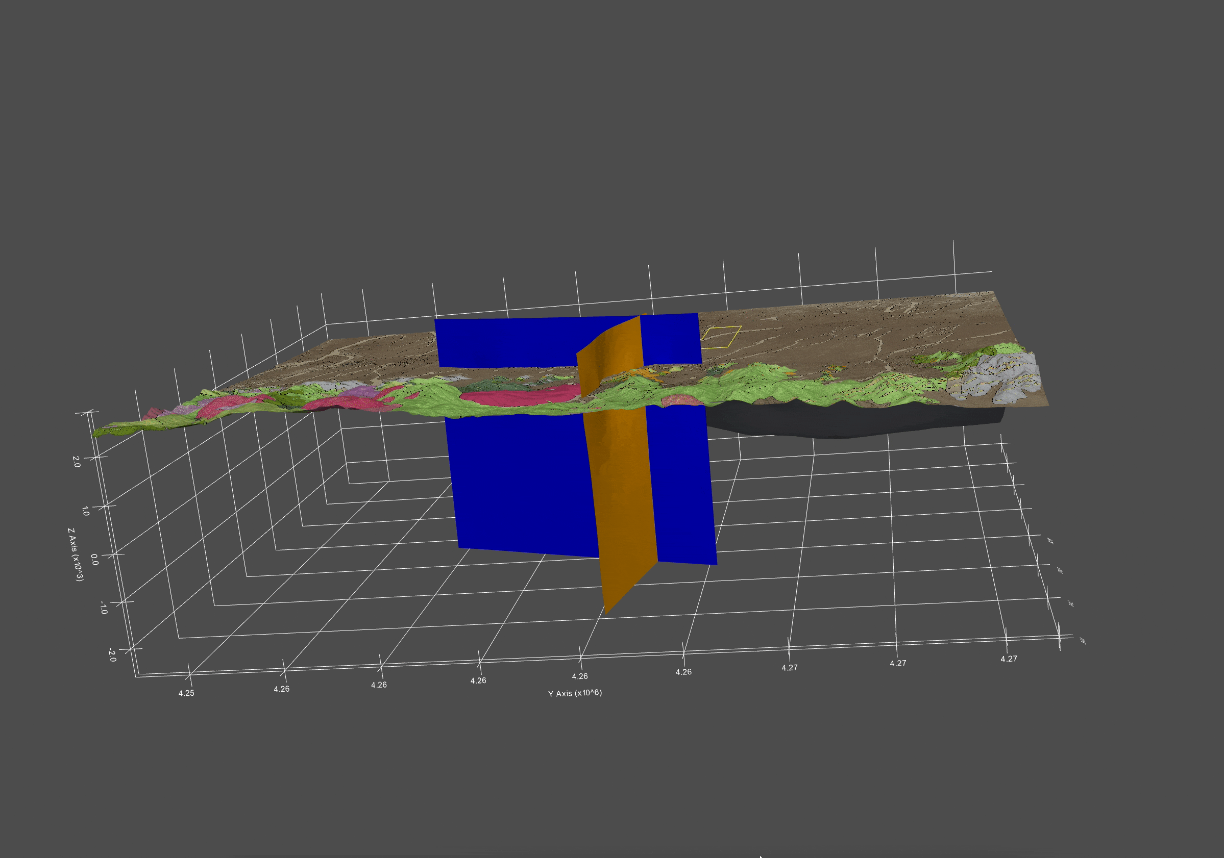
Fig. 9 The model shows the geologic map on top that was created with outcrop information. The geologic model has three main parts: the two main faults (orange and blue planes) and the top of the granite layer (the gray plane).#
The data is given by the Utah Forge Geothermal Database. [14] Visualization is done by pyVista. [15]